Our Recording Area
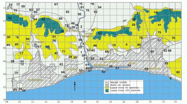
The map above shows our recording area. Click/tap the map for the key to the sites shown.
What we define as our recording area runs from Ferring Rife in the West to the Brighton Marina in the East and from the coast as far inland as Henfield Levels in the North.
The western boundary of the SDOS area is O.S. Easting 08 including Ferring Rife; part of Harrow Hill and Chantry Hill.
The eastern boundary is Easting 35 including the entire Sheepcote Valley, part of East Brighton golf course and Bevendean Down.
The northern boundary is Northing 15.
Note: some of the locations listed on this and other pages, including the Ladywell ringing site, are on private land and require the landowner's permission to access them.
Reserves in Our Area
Please see their individual pages for more information.
- Lancing Widewater LNR (TQ204043)
- RSPB Adur Estuary Reserve
(TQ213048)
Other Birdwatching Sites
A page listing other sites with OS grid references, mostly outside our area, can be found on the Other Birdwatching Sites page
Local Links
Reporting
To report sightings, both inside and outside our recording area, we advise that this should be done using BTO BirdTrack
Bird Track and the SOS recent sightings page, along with our own User Group, can be used to obtain information on sightings in our area.
Help in Using OS Grid References
Navigating to a site using the grid ref.
Guidance on converting OS grid references for use in navigation apps on smart phones can be found on the How to Use Grid References page
Finding the Grid Reference for a place
Dr Roger Smith has produced a tutorial on grid references, which includes guidance how to use a web-based tool to easily find the grid reference for a specific point on the ground.
Download the SDOS Grid Reference Guide


